Lahaul and Spiti
General Info
· Lahaul
· Baralacha Range
· Chandra Valley
· Bhaga Valley
· Keylong
· Chandra-Bhaga Valley
· Great Mountain Mass
· Lingti Plains
· Climate
· Kaza
· Pin Valley
Other Places of Interest
Passes
· Baralacha Pass
Rivers
· Chandra River
· Chandra - Bhaga
· Spiti River
Glaciers
· Bara Shigri Glacier
Lakes
· Chandratal Lake
· Suraj Tal Lake
People
· Lahaulas
· Tradition & culture
· Spiti
Religion
Fairs and Festivals
History
· Lahaul
· Spiti
Visual Delights

![]()
|
Spiti Spiti is a geographical entity of its own, separate from the neighboring Lahaul region. Spiti is separated from Lahaul by an offshoot of the main Himalayan range. The road over this range runs across the Kunzam La pass (4,500 m). Spiti is also linked by road with the Satluj valley. The Manali-Leh route crosses the Rohtang Pass (3,915 m) and then passes through the Lahaul region before reaching Spiti. |
An introduction to Spiti. (Download Realplayer) |
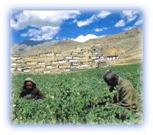 |
| Farmers at work in a village in Spiti Credit: Discover India |
Spiti is separated from neighboring Kinnaur to the southeast by a high mountain range which is an offshoot of the main Himalaya.
Spiti was closed to tourists for a long time due to its strategic location. However, it has been thrown open for tourism recently, and the previously isolated people and culture are gradually coming into contact with the people that visit the region.
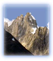 |
| Challenging rock face in Spiti Credit: Karamjeet Singh |
A large part of Spiti remains blocked from the rest of the country due to the closure of high passes by snow in winter. Spiti is more desolate and barren than Lahaul and resembles, to a considerable degree, Ladakh and Tibet. Spiti is generally higher and the terrain here is more rugged than in Lahaul. Spiti is ringed by a mountain wall of 6,000 m high peaks. The incredible landscape of these mountains includes some of the deepest gorges and canyons on earth, with vertical drops plunging down thousands of feet. In the north, the Chocho-Lang Kilta has a height of over 6,400 m, while in the east lies the main Himalayan range whose peaks soar to more than 7,000 m. The Manirang peak, with an elevation of more than 6,500 m, is to the south. The towering Kunzam range divides Spiti from Lahaul in the west.
The natural access to Spiti is along the Spiti River from the Satluj Valley (Kinnaur). A motor road over the Kunzam La pass links it with Lahaul. However, this road is open only for a few months in summer.
All rights reserved