Lahaul and Spiti
General Info
· Lahaul
· Baralacha Range
· Chandra Valley
· Bhaga Valley
· Keylong
· Chandra-Bhaga Valley
· Great Mountain Mass
· Lingti Plains
· Spiti
· Climate
· Kaza
· Pin Valley
Other Places of Interest
Passes
· Baralacha Pass
Rivers
· Chandra River
Spiti River
Glaciers
· Bara Shigri Glacier
Lakes
· Chandratal Lake
· Suraj Tal Lake
People
· Lahaulas
· Tradition & culture
· Spiti
Religion
Fairs and Festivals
History
· Lahaul
· Spiti
Visual Delights

![]()
|
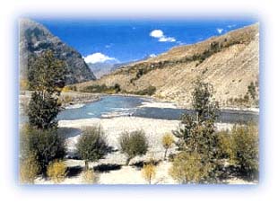
Chandra-Bhaga (Chenab) River In its upper course through the Lahaul Valley, the Chenab River is known as the Chandra-Bhaga. It is formed by the rivers Chandra and Bhaga and hence the name. After the two rivers meet at Tandi, the combined river assumes the name Chandra-Bhaga. As it flows through Lahaul, this river has laid thick deposits of sediments. It is in spate during the summer season when the snow on the mountains melts. Flash floods occur with regularity in the early afternoon in summer. They have been known to wash away hundreds of cattle each year. The Chandra-Bhaga River freezes occasionally in the winters. |
Chandra River. (Download Realplayer) |
 |
| Chandra and Bhaga rivers meet at Tandi Credit: Discover India |
This is an important tributary of the Indus River, which flows through the western Himalaya. The Chenab River flows in a northwesterly direction through the cold desert valley of Lahaul. In its middle course it enters the famous Pangi Valley, which bears thick virgin forests. Many small snow-fed nalas and rivers join the Chenab River in its upper and middle courses.
The Chenab flows along the northern base of the Pir Panjal range before entering the Doda area of Jammu and Kashmir and it cuts across this range through a spectacular gorge. Then it flows along the southern base of this range before flowing southwards and entering the plains. The important Himalayan tributaries of Chenab which join it in its lower course are the rivers Jammu Tawi and Bhoga.
Spiti River
The Spiti is a large tributary of the Satluj River in Himachal
Pradesh. It rises as a series of small snow-fed streams from
the glaciers on the northern slopes of the main Himalayan range
in the Spiti area. It winds its way across the Spiti Valley in
a generally southeasterly direction and flows into the Satluj
at Namgia soon after the latter river enters Indian territory.
Waters draining the famous Pin Valley area are also a part of
the Spiti river system.
The valley of the Spiti River resembles the Tibetan land which lies north across the international border. Its position across the main Himalayan range deprives it from the benefit of the southwest monsoons which cause widespread rains in most parts of India from June to September. The mountains are barren and largely devoid of a vegetative cover. Vegetation is restricted to sheltered moraines and strips along channels formed by the melting snow of the mountains.
Huge mountains rise to very high elevations on either side of the Spiti River and its numerous tributaries. The valley has largely been influenced by the action of ancient glaciers. Almost barren river terraces have been deposited by the river and its tributaries. The river attains peak discharge in late summers when snow on the mountains melt. The Spiti River freezes occasionally in winter.
The main settlements that have come up along the Spiti River and its tributaries are Hansi and Dhankar Gompa.
All rights reserved