Lahaul and Spiti
General Info
· Lahaul
· Baralacha Range
· Chandra Valley
· Bhaga Valley
· Keylong
Great Mountain Mass
Lingti Plains
· Spiti
· Climate
· Kaza
· Pin Valley
Other Places of Interest
Passes
· Baralacha Pass
Rivers
· Chandra River
· Chandra - Bhaga
· Spiti River
Glaciers
· Bara Shigri Glacier
Lakes
· Chandratal Lake
· Suraj Tal Lake
People
· Lahaulas
· Tradition & culture
· Spiti
Religion
Fairs and Festivals
History
· Lahaul
· Spiti
Visual Delights

![]()
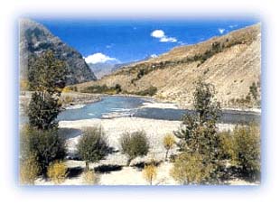 |
| Chandra and Bhaga rivers meet at Tandi Credit: Discover India |
Chandra-Bhaga Valley
The rivers Chandra and Bhaga merge at Tandi to form the
Chandra-Bhaga or Chenab River. Thereafter this river flows
through an open valley to Thirot from where it enters Chamba
District. In Lahaul, this valley is known as the Pattan Valley.
Great Mountain Mass
Ice and snow are important factors in the region. The great
mountain mass occupies a position between the Chandra and Bhaga
valleys. It extends as an offshoot of the main Himalaya with
peaks soaring to over 6,400 m. The Baralacha Pass is also a
part of this great mountain mass.
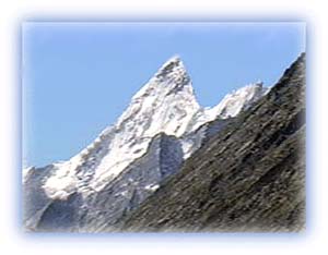 |
| The lovely White Sail peak, viewed from Batal Credit: Karamjeet Singh |
Standing like a huge fort, this mountain mass contains high peaks, valleys, snow-fed streams, glaciers and ice fields. Three important rivers -- Chandra, Bhaga and Yunam -- rise from near the Baralacha Pass.
This landmass is sparsely populated. Settlements are few, though graziers often ascend to the high alpine pastures in summer with their animals.
Lingti Plains
This is a desolate and barren tract located to the north of the
Baralacha Pass. It covers an area of 260 square kilometers and
average elevation is more than 4,400 m. The small rivers Lingti
and Yunam flow through these plains before entering the Zanskar
region of Ladakh.
The Lingti plains are largely uncultivated and uninhabited. In summer, a good growth of grass covers the slopes, which are grazed by the stock of migratory graziers.
All rights reserved