Lahaul and Spiti
General Info
Baralacha Range
Chandra Valley
Bhaga Valley
Keylong
· Chandra-Bhaga Valley
· Great Mountain Mass
· Lingti Plains
· Spiti
· Climate
· Kaza
· Pin Valley
Other Places of Interest
Passes
· Baralacha Pass
Rivers
· Chandra River
· Chandra - Bhaga
· Spiti River
Glaciers
· Bara Shigri Glacier
Lakes
· Chandratal Lake
· Suraj Tal Lake
People
· Lahaulas
· Tradition & culture
· Spiti
Religion
Fairs and Festivals
History
· Lahaul
· Spiti
Visual Delights

![]()
|
Lahaul Lahaul is separated from Spiti by an offshoot of the main Himalayan range. The road over this range runs across the Kunzam La pass (4,500 m). The Lahaul region is approached by road from Kulu over the famous Rohtang Pass (3,915 m). A large part of Lahaul remains cut-off from the rest of the country due to the blockage of high passes by snow in winter. |
First impression of Lahaul. (Download Realplayer) |
 |
| The famous Baralacha Pass Credit: Discover India |
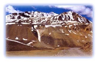
Baralacha Range
The Baralacha range, having an average elevation of 5,500 m,
separates this region from the cold desert of Ladakh in the
north. The Manali-Leh motor road runs over the Baralacha Pass,
and crosses over into Leh. Tibet lies to the east of this
region. A lofty mountain range, which is an offshoot of the
main Himalaya and has an average height of 5,000 m, separates
the Lahaul-Spiti district from Kinnaur in the south-east.
Chamba and Kulu lie to the west and southwest of this region.
Chandra Valley
This valley is formed by the Chandra River which merges with
the Bhaga River at Tandi to form the Chandra-Bhaga or Chenab
River. Locally, this valley is also known as Rangoli. The upper
parts of the Chandra valley contain a vast snow-bed near the
Baralacha Pass. It is largely uninhabited and consists of high
mountain peaks, large glaciers and vast snowfields.
 |
| The Chandra river in its upper course, enroute to Kunzum La Credit: Karamjeet Singh |
Alpine vegetation comes up in the region in the form of pastures when the snow melts in summer. Migratory graziers camp on these pastures with their cattle. There is no habitation for about 72 km along the length of the Chandra River from its source. Koksar, a small hamlet is the first settlement in the Chandra Valley. There are several villages on the right bank downstream of Koksar, but the left bank is like a steep wall. The Manali-Leh motor road crosses the Chandra River at Koksar.
Most of the land at lower altitudes downstream of Koksar is under cultivation. The villagers have planted fields on terraces to provide them with fuelwood and fodder for their cattle. This region produces a considerable quantity of seed potatoes.
 |
| A meandering stream and green paddy fields, Lahaul Credit: Discover India |
Bhaga Valley
The valley formed by the Bhaga River is locally known as Gara.
However, the portion from Darcha to Keylong is called Stod.
This valley is a desert-like tract with mountain slopes largely
devoid of a vegetative cover. It starts from the southwestern
base of the Baralacha Pass and consists of a narrow gorge till
the mountain hamlet of Darcha.
Downstream of Darcha, the Bhaga valley widens. There are many villages between Darcha and Tandi, where the Bhaga River merges with the Chandra River to form the Chandra-Bhaga or Chenab River. The terraces between Darcha and Tandi are under cultivation. The middle slopes consist of grasslands. The forest department is planting trees and shrubs on these slopes in an effort to increase the tree cover, and to solve the problem of fuelwood and fodder.
Keylong
Keylong is the headquarters of the Lahaul and Spiti district.
It is a small town located on the right bank of the Bhaga River
downstream of Darcha.
All rights reserved