Ladakh himalayas
General Info
· Villages
· Valleys and plateaus
· Dras Valley
· Dras
· Suru Valley
· Kargil
· People
· Siser La
· Tulimpati La
· Shyok Valley
· Murgo
· Burtsa
· Daulat beg Oldi
· Digar La
· Karakoram Pass
· Khardong La
· Indus Valley
· Chanthang Plateau
· Rupshu
· Salt Lake Valley
· Puga Valley
· Lakes
· Passes
· Glaciers
· Rivers
· People
· Religion
· Fairs and festivals
· Other places of interest

![]()
| The Nubra Valley The 18,640 feet high Khardung La pass forms the divide between the Nubra Valley and Leh. After crossing the Khardung La, one descends to a place called Khalsar, situated on the left bank of the Shyok River. One route bifurcates towards the Bubra Valley right across whereas the other route follows the Shyok River towards Dikshit and further towards Turtuk in Pakistan occupied Kashmir. After crossing the bridge over the Shyok River at Koyak, the wide and beautiful Nurba Valley starts. |
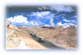 |
| Army convoys travel regularly over the Tanglang La and Nubra valley. Credit: Discover India |
People used to go as far as Mecca and Medina in the Middle East for the Haj pilgrimage via this route. Big caravans of hundreds of horses and double-humped Yarkandi camels would trek to Kashmir, which was one of the major trade centres on the route between the Gangetic plains of India and the high mountainous regions of Central Asia. The traditional border trade was stopped only in the late 1950s when the Aksai Chin area came under Chinese control.
Nubra Valley lies about 10,000 ft above sea level and is about 3-4 miles wide. It presents features not seen anywhere else in the Himalayan valleys. The valley bottom is composed of alluvial sand and stones over which the river flows in a broad bed with many channels that leave the main stream at various points and enclose in their course a number of islands. The river is fed by many tributaries and streams.
At Panamik, a full circle of peaks surrounds the flat sea of the central plain dotted with villages. Here lies a valley cut off from the world -- a hidden secret land of Nubra. Mountains rise on both sides abruptly from the valley in great masses, forming walls of solid rock broken only by narrow side gorges that strike directly into the heart of the range, dividing the facing wall into enormous sections. The gorges have formed perfectly and symmetrical "fans" radiate out broadly from the narrow openings and extend to the middle of the valley or beyond. On these "fans" are situated the villages, scattered throughout the valley at fertile spots. The hot water spring at Panamik is always inviting to the trekkers and makes a very good camping ground.
The Nubra River originates from the Siachen glacier in the northwest and the Terong glacier in the east. It meets the Shyok River at Lunghzhung. The wide open valley is flanked by high barren mountains on both sides. The area is rugged and barren with steep cliffs, but down the valley there is greenery with some forests at river bed level.
The bottom of the valley gradually ascends to Changlung (Susoma) at 11,000 ft. Between Panamik and Changlung there is a long trek over sand interspersed with rocky debris, a wilderness with several large granite boulders, rounded by glacial action, whose smooth surfaces are covered with skilfully carved "Om Mani" and other Buddhist prayers.
Susoma is a small dwelling place at the confluence of Nubra and Tulimpati Chu. It originates from the Siachen Kangri glacier. Nubra forms a wide glaciated valley. There is hardly any habitation beyond this point and it is a long dry river bed with high barren rocky mountains on both sides with lofty snow peaks. The Tulimpati Chi comes from the Saser glacier. The western side is dominated by the Teram Kangri group of peaks.
All rights reserved