Kumaon himalayas
General Info
· Pithoragarh
· Dharchula
Other places of interest
· Nainital
Rivers
Flora and Fauna
· Tigers
· The Corbett Saga
People
· Kumaonese
· Bhotias
· Bhotias of Munsiari
· Bhotias of Dharchula
· Livelihood
· Recent changes in lifestyle
Economy
History

![]()
| Gori Valley The Gori(ganga) Valley offers excellent trekking and climbing opportunities. However, infrastructure is almost non-existent in this region. The road ends at Munsiari (or Munsiary), and from here one has to trek to reach Milam, which is the largest village in the Munsiari area. Incidentally, the portion of the Gori valley from Munsiari to Milam is called Johar, from the grain that is harvested in the non-trading season. |
 |
| Nainital - popular tourist attraction in summers Credit: Yogesh Wadadekar |
Munsiari lies in the northern part of the Pithoragarh of Kumaon. To its north lies Tibet. The Panchchuli range separates it from Dharchula in the east and forms a cultural, social and linguistic barrier between the Bhotias of Johar Valley and the inhabitants of the Darma, Dyans and Chandans valleys.
Munsiari is made up of three distinct tribal tracts -- Malla Johar, Talla Johar and Gauri Phat. The upper zone of Munsiari lies between 3,300 and 4,500 m and consists of a number of villages falling in the Malla Johar tract. The lower zone lies between 1,000 and 2,500 m and consists of the villages of the Talla Johar and the Gauri Phat tracts. These two zones have different climatic conditions, which has influenced the lives of the Bhotias living in the area. The Malla Johar region remains under a thick blanket of snow for five months in a year. The bulk of the precipitation in the region is in the form of snow. Due to high altitude and the short growing season, the only crops that can be grown are potatoes, barley and mustard.
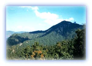 |
| Green wooded hills surround Nainital. Credit: Yogesh Wadadekar |
The Talla Johar and Gauri Phat tracts lie at relatively lower altitudes. The total annual rainfall in the region is about 150 cm, which is much more than that of the Malla Johar tract, which lies at a higher elevation. There is more rainfall in regions lying below an elevation of 2,000 m. Two crops are grown in a year -- the main ones being wheat, barley, paddy and maize. Climatic conditions are also favorable for the cultivation of fruits.
The largest village in the Munsiari area is Milam (11,200 ft), which is located at about 3 km from the glacier at an altitude of 4000 m. The Goriganga rises at this glacier. Milam was at one time a very large village as a result of its being an important post on the trade route to Tibet. The famous Pandit brothers, explorers in the 19th century, were natives of Munsiari.
The Gori Valley also offers some excellent climbing opportunities in the form of peaks like Chiring We (6,559 m), Kalabaland Dhura (6,105 m), Suitilla (6,373 m), Rajrambha (6,537 m), Tirsuli (7,074 m) and Hardeol (7,151 m). The Inner Line border restrictions have been relaxed in recent times, which allows trekkers to explore hitherto unexplored valleys. Foreigners, however, may still face restrictions as they get close to the Indo-Tibet border.
All rights reserved