Garhwal himalayas
General info
· Uttarakhand
· Eastern Garhwal
· Route to Badrinath
· Haridwar
· Rishikesh
· Devaparayag
· Srinagar
· Rudraprayag
· Chamoli
· Joshimath
· Badrinath
· Valley of Flowers
· Hemkund Sahib
· Route to Kedarnath
· Nanda Devi Sanctuary
· Nanda Devi
· Inner Sanctuary
· Outer Sanctuary
· Present-day Scenario
· Western Garhwal
Other Places of Interest
· Uttarkashi
People
· Jaunsaries
· Jadhs
· Marchas
· Bhotias
Religion
· Gods and Goddesses
Flora and Fauna
· Wildlife

![]()
|
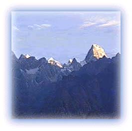
Mana and Niti Northeast of Badrinath is another impressive cluster of mountain peaks. The mountains rise almost on the Indo-Tibetan border with Mana and Kamet as the principal peaks. Mana itself marks the eastern extremity of the Zanskar range. It lies between the pass of the same name and the Niti Pass. |
 |
| Mana Peak, northeast of Badrinath Credit: Karamjeet Singh |
The Mana Valley lies in the hinterland of Badrinath. Mana, the last village on the Indian side of the border with Tibet, is the largest settlement of a seminomadic group called Marchas. Their houses are made of stone, with roofs of slate resting on wooden members. The Mana Pass, situated further ahead, was used in the past by the Marchas to cross over into Tibet for trade. It is one of the most difficult passes in the region. In those days, Mana must have been a big and prosperous village due to the trade: references are made to it by Jesuit priests trying to reach the Tibetan kingdom of Guge in 1624. However, the Chinese invasion of Tibet, plus "inner line" restrictions on the Indian side, meant an end to the trade, depriving Mana of its reason for existence in these harsh and rarefied altitudes. Today, the people of the region survive by petty retailing during the pilgrim season in Badrinath. In winter, the entire village moves down the valley, cattle and all, to wait out the winter snows.
The Niti Valley is situated to the east of the Mana Valley in the hinterland of Joshimath. Niti, located at an elevation of 3,600 m, is the most important village of the valley. To the north of this village is the Niti Pass (5,800 m) leading to southern Tibet. The region receives heavy snowfall. As a result, it is sparsely populated and people survive by rearing animals.
All rights reserved