Garhwal himalayas
General info
· Uttarakhand
· Eastern Garhwal
Sacred Ganga
· Gangotri
· Gaumukh
· Route to Gangotri
· Dharali
· Harsil
· Towards Gangotri
· Wilson Saga
· Yamunotri
· Tons Valley
· Har-Ki-Dun Valley
· People
Other Places of Interest
· Uttarkashi
People
· Jaunsaries
· Jadhs
· Marchas
· Bhotias
Religion
· Gods and Goddesses
Flora and Fauna
· Wildlife

![]()
|
Western Garhwal Moving westwards from the Alaknanda-Saraswati divide, one enters the Gangotri region. Early maps for this region were fairly vague and misleading. It was not until the 1936 surveys of Maj Gordon Osmaston were carried out, covering ground from the Satluj basin in the west to the borders of Nepal in the east, that some semblance of order was imposed as far as the authenticity of heights and positions of mountains was concerned. One still gets to hear heroic tales of the surveyors braving blizzards and being snowbound for days, to be rescued along with their "khalasis" in the last stages of survival, but still clutching their precious plane-table survey! |
Himalayan Foothills. (Download Realplayer) |
 |
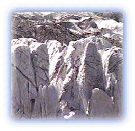
| Ice walls of the Great Gangotri glacier Credit: Karamjeet Singh |
Here is a great 40 mile long group of peaks and glaciers that give rise to the various source streams of the holy Ganga. The major glaciers in the region are the Gangotri, Chaturangi and Raktavarn, which lie adjacent to each other. Separated from them by massive walls of peaks lie the Satopanth and Bhagirathi glaciers.
Sacred Ganga
The Gangotri region is the place where the holy Ganga river
rises in the Great Gangotri Glacier. It is a 30 km long river
of ice, which gives birth to the main headwater -- the
Bhagirathi. The Ganga emerges from the depths of a glacier and
rises at Gaumukh, an ice cave. At one time, the ice cave was
apparently shaped like a cow's mouth, and hence the name.
All rights reserved