Garhwal himalayas
General info
· Uttarakhand
· Eastern Garhwal
· Route to Badrinath
· Haridwar
· Rishikesh
· Devaparayag
· Srinagar
· Rudraprayag
· Chamoli
· Badrinath
· Mana and Niti
· Valley of Flowers
· Hemkund Sahib
· Route to Kedarnath
· Nanda Devi Sanctuary
· Nanda Devi
· Inner Sanctuary
· Outer Sanctuary
· Present-day Scenario
· Western Garhwal
Other Places of Interest
· Uttarkashi
People
· Jaunsaries
· Jadhs
· Marchas
· Bhotias
Religion
· Gods and Goddesses
Flora and Fauna
· Wildlife

![]()
|
Joshimath Joshimath is described in the ancient scriptures as Kartikeyapura, because the Katyuri kings named it after their God, Kartikeya. Jyotirmath, or Joshimath, located at a height of about 6,000 ft, is one of the four great "maths", or monasteries, established by the great Adi guru Shri Shankaracharya in the 8th century AD. Joshimath was the heart of religious and cultural activity in those days and continues to be the same even today. |
Joshimath has to be a large place because... (Download Realplayer) |
 |
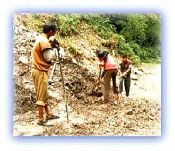
| Landslides, a frequent problem in Garhwal. Credit: Raj Shirole |
Just below Joshimath two rivers, the Alaknanda and the Dhauliganga, meet at the confluence of Karnaprayag. The river Dhauliganga, coming from the Niti Valley, is approachable from Joshimath by vehicle up to Malari town and beyond. The entire route is lined with thick deodar forests. From Malari, one track goes towards Niti village via Kailashpur, Farkia, Bampa and Ghamsali. The entire valley throbs with activity in summer. Niti is the last village of the valley and from here the track goes towards the Niti Pass (5,299 m) and Marchokla.
The inhabitants of these valleys are simple, sturdy and dynamic like their Jauhari counterparts in Kumaon.
Joshimath is a fairly large town. It has to be, since most of Badrinath arrives here to spend the winter months when the shrine of Badrinath remains snowbound for six months. It is the winter shrine of Badrinath which is worshipped here during the winter months. Today, it is a comparatively modern town with small hotels, modern shops, and even a cinema.
 |
| Glorious Garhwal Credit: Unknown |
After Joshimath, the army takes over, and there is an interesting one-way system. The traffic from Joshimath travels for a few hours to reach a place called Pandukeshwar, where the road is broader. Here the vehicles wait, while the traffic from Badrinath comes down and passes them. After that, the vehicles are allowed to move higher up the mountain. The ride further from here can be described as thrilling. The roads are well- maintained although very narrow. The area is extremely vulnerable to landslides and it is not uncommon to be stopped for a few hours or at worst a few days because of landslides due to heavy rain. As the narrow road winds steeply up the mountain, one encounters sharp hairpin bends which can be exciting or scary, depending on one's sense of adventure!
Finally, one reaches the windswept barren valley which harbors Badrinath.
All rights reserved