Ladakh himalayas
General Info
· Villages
· Valleys and plateaus
· Lakes
· Passes
· Glaciers
· Rivers
· Indus
Gurtang river
· River Shigar
· Shigar river (south)
· River Dras
· River Shiugo
· River Suru
· Shyok river
· Chang Celmo river
· Chipshap river
· Galiwan river
· Nubra river
· Saltoro river
· Gilgit river
· River Ghizar
· River Hunza
· River Shimshal
· Astor river
· Shaksgam River
· People
· Religion
· Fairs and festivals
· Other places of interest

![]()
| Hanle river The Hanle River is a short left bank tributary of the Indus River. It rises in the snowy wastes on the northern slopes of the Zanskar range in eastern Ladakh in the state of Jammu and Kashmir, India. Two feeder streams emanating from glaciers join to form the main stream of the Hanle River. One flows in from the east while the other joins from the west. The main stream follows a north by northwest course and joins the Indus River near Loma. |
The Hanle River drains the area to the east of Lake Tsomorari in Rupshu. The glacial action has played a dominant role in shaping the topography of the catchment of this river. The principal geomorphic features include hanging valleys, moraines and glacial lakes. This river often floods its banks during the late summers.
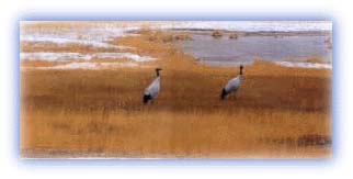 |
| Rare black necked cranes Credit: Discover India |
Gurtang River
The Gurtang River is a tributary of the Indus River in the
Ladakh region of Jammu and Kashmir. It rises from a glacier on
the southern slopes of the Ladakh region. Thereafter, it flows
down to the Indus valley and joins the Indus at an elevation of
4,200 m above sea level.
Glaciers have shaped the entire catchment area of this river. The prominent features include hanging valleys, amphitheaters, glacial depressions, moraines and cirques. The river has a very steep gradient from its source to its confluence with the Indus River.
The entire region is devoid of vegetative cover. This is due to the high elevation and its location in the rain-shadow area of the main Himalayan range. No human habitation is found along the Gurtang although its valley is occasionally visited by migratory graziers and travelers moving along the Indus River.
All rights reserved