Zanskar himalayas
General info
· Shingo La photo-feature
Approaching Zanskar from the Suru Valley
· Panikhar
· Penzella Pass
· Tangol
Zanskar Valley
· Shagma Karphu
· Padam
· Karsha
Rivers
· Khurana River
People
· Rangdom Gompa
· Phuktal Gompa photo-feature

![]()
| Zanskar River The Zanskar River is one of the largest tributaries of the Indus River in Ladakh. Its headwaters are known as the Tsarap Chu and originate from the snows on the north-facing slopes of the main Himalaya. These are joined by another feeder channel flowing in from the northwest and forming the Zanskar River. |
 |
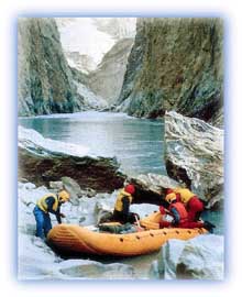
| River rafting on the Zanskar River Credit: KOA |
The entire catchment area of the Zanskar River has been formed by the action of glaciers. Its valley is U-shaped and a number of hanging valleys open into it. Important tributaries of the Zanskar are:
| the Tsarap Chu, which rises from the north-facing slopes of the main Himalaya and joins the main river near Padam; | |
| the Doda, another snow-fed stream; | |
| the Khurana River. |
The Zanskar River has cut a deep gorge across the Zanskar range in its middle course. It flows into the Indus about 40 km downstream of Leh.
The vegetative cover in the Zanskar catchment is confined to occasional tufts of grass on the moraines and small clumps of vegetation along channels formed by snow-melt waters. Human habitation is sparse. The main settlements along the Zanskar River are Abring and Padam.
All rights reserved