Zanskar himalayas
General info
· Shingo La photo-feature
Approaching Zanskar from the Suru Valley
· Panikhar
· Penzella Pass
· Tangol
Zanskar Valley
· Shagma Karphu
· Padam
· Karsha
Rivers
· Zanskar River
People
· Rangdom Gompa
· Phuktal Gompa photo-feature

![]()
| Khurana River The Khurana River is a tributary of the Zanskar River, which in turn drains into the Indus near Leh in Jammu and Kashmir. The Khurana rises from the snow-waters at the base of the northern slopes of the Zanskar range in southeastern Ladakh. |
 |
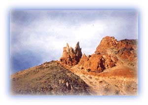
| Spectacular rock faces Credit: Jarkko Lavinen |
The Khurana River flows northwest to join the Zanskar in the area northwest of Markha. It flows in a valley between the Zanskar range in the west and its offshoot in the east. Markha is located in this offshoot range.
The entire catchment area of this river has been shaped by the action of glaciers and running water. Its upper valley is U- shaped and was probably covered by a glacier in the past. Moraines laid down by glaciers are found in this valley. Waterfalls occur in the side valleys of the Khurana.
Alpine meadows are found in the depressions. The rest of the valley is largely devoid of vegetative cover as it lies in the rainshadow of the main Himalayan range. Human habitation is very sparse.
All rights reserved