Nepal Himalayas
General Info
· Solo Khumbu
· Namche Bazar
· Thyangboche
· Pangboche
· Kalapattar
· Pheriche
· Buddhism in Khumbu
· People: Sherpas
· Mount Everest
· The Quest for Everest
· Early Years
· The 1950s
· Sherpas on Everest
· Central Nepal
· Mustang
· Jomsom
· People: Thakalis
· Muktinath
· Manang valley
· Bryagu village
· Manang village
· Nyasang Division
· Western Nepal
· Jumla
· Sukhadik
Photo Feature:
High Altitude Sickness
Endangered Species
Protected Areas
Yaks
The Yeti Factor

![]()
|
Annapurna region |

|
Map of the Annapurna Region Credit: Scott Yost |
|
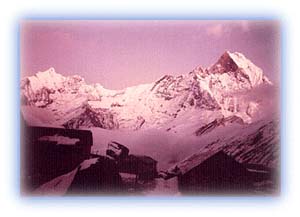
Machhapuchhare, the Fish Tail peak. Climbing has been banned on
this peak for religious reasons. Credit: Stan Armington |

|
|
Annapurna Base Camp at dusk. The sacred Machhapuchhare peak stands to the right in the background. Credit: Scott Yost |
All rights reserved