Tibet himalayas
Trans Himalayas
· Lhasa
· Shigatse
Climate & vegetation
· Rainshadow Effect
People
Religion
The Yeti Factor
Photo Features
· Glimpses of Buddhism
· Invaluable Butter
· Agriculture
· Kailash and Mansarovar
· Jokhang Temple

![]()
|
General info Tibet is situated on the Qingzang (Qinghai-Tibet) Plateau. This is the highest plateau in the world with an average elevation of 4,875 m (more than 16,000 ft), and the Tibetan Plateau is also called the Roof of the World. In 1964, Tibet became an Autonomous Region of China. It is surrounded in the north and east by other provinces of China, in the south and west by Burma, India, Bhutan, and Nepal. The capital of Tibet is Lhasa. |
An introduction to Tibet. (Download Realplayer) |
Tibet is surrounded on three sides by vast mountain systems: the Kunlun mountains of Central Asia in the north, the Karakoram range in the west and the Himalayas in the south.
 |
|
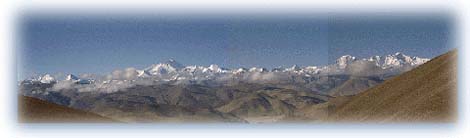
View from Pang La (pass) at 17,000 ft on the jeep road to the village of Kharta in western Tibet. The panorama of the Tibetan Himalayas includes four of the world's tallest mountains -- Makalu (far left), Everest and Lhotse (center) and Cho Oyu (right) are all over 8,000 meters high. Credit: W. Spiegelman |
Trans Himalayas
Tibet lies in a region known as Trans Himalayas. As the term
suggests, Tibet lies beyond the main Himalayan range. The Trans
Himalayan region itself is an ill-defined mountain region
covering an area of about 1,000 km (600 miles) and having a
width ranging from 225 km (140 miles) to about 32 km (20
miles). Unlike the main Himalayas, the Trans Himalayan
mountains are not divided by deep river gorges. On the Roof of
the World, passes average 5,330 m (17,500 ft) in height, with
the highest being the Chargoding Pass at a height of 5,885 m
(19,308 ft).
The first recorded European exploration of the Trans Himalayas was carried out by the Swedish explorer Sven Hedin. Hedin explored Tibet and the Xinjiang (Sinkiang) region extensively. He identified the sources of the Brahmaputra, Indus, and Satluj rivers, and, in 1906, explored and named the Kailas Range.
 |
|
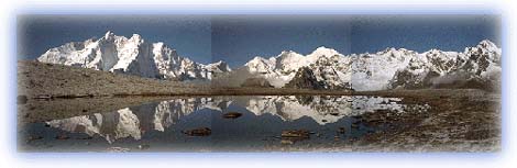
Everest panorama. From left to right are Makalu and Chomolonzo, Lhotse, Lhotse shar, and the Kangshung face of Mt Everest, first climbed by an American team led by Lou Reichardt. Credit: W. Spiegelman |
The southern part of Tibet falls within the Himalayan region. Some of the world's highest mountains define the southern border of Tibet. These include Mt Everest (8,848 m) -- the highest mountain in the world, Namcha Barwa (7,756 m / 25,445 ft) -- around which the Brahmaputra carves a fantastic gorge to enter India, and Gurla Mandhata (7,728 m / 25,355 ft). Running north of the main Himalayan range is the Kailas Range, named thus by Hedin.
 |
|
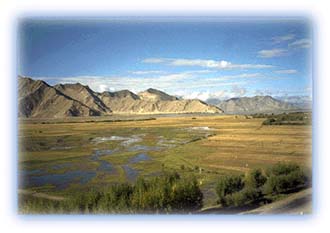
The valley of the Tsangpo as seen from the Lhasa highway, between Lhasa and Shigatse. From here, the road continues across western Tibet to the edge of the Tibetan plateau, then drops thousands of feet down to the border with Nepal. Credit: W. Spiegelman |
Between the two ranges lies the river valley region extending for about 1,000 km from west to east. The Brahmaputra River (known in Tibet as the Yarlung Tsangpo) flows from west to east through most of this region. The Tibetan plateau is the source of some of the biggest rivers in the Himalayas. The Brahmaputra, Indus and Satluj are three Trans Himalayan rivers that originate in Tibet, cut across the main Himalayas making fearsome gorges and then flow towards the plains.
 |
| Map of Tibet. Tibet is officially Tibet (Chinese Xizang) Autonomous Region, China. |
All rights reserved